The Wind River Canyon is one of the two major scenic features I've specifically made room for on the layout. Wind River Canyon is the largest - the second, where the tracks of the Cody Branch cross over the highway between Powell and Cody, occupies a very small area indeed.
The track for the Wind River Canyon is very simple:
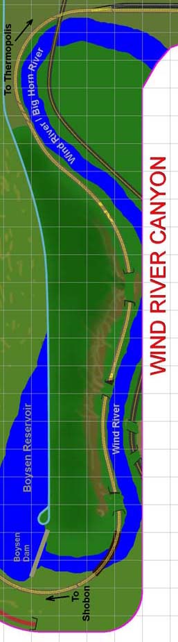
As was the case for Casper, this diagram has been rotated 90 degrees counter-clockwise.
There are about 25 feet of track through this area, starting from where the track passes by the Boysen Dam at the bottom of the diagram, and ending about where the track crosses the road at the top, near Thermopolis. The curve in the corners are about 45 inch radii; all the rest in this area are 90 inches or greater.
The Wind River is, obviously, the lowest elevation in the canyon. The track is some 30 feet or so higher, across the river from the operator's aisle. The mountain extends upwards behind the track, sometimes very steeply. There is no upper center peninsula, so that the mountains can rise high up near the ceiling and properly dwarf the trains (though they still will be nowhere near their scale height). The mountains also rise up slightly towards the aisle, and sections of the road that is now US20 will be seen on the aisle side of the river.
Wind River Canyon is one my favorite areas along the CB&Q line.