
Here's the lower deck:
The Northern Pacific
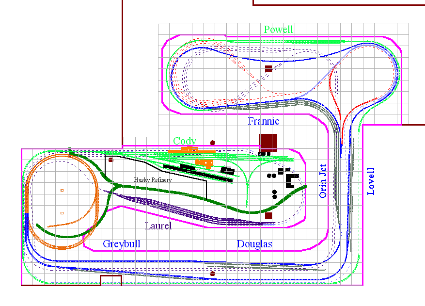
Laurel, on the lower level of the layout, is the NP / CB&Q junction point. It's at the lower left middle of the diagram. As you can see, at each end of that yard the tracks disappear into the backdrop (left end) and under a highway overpass (right end). While the hidden trackage is kinda hard to see, you can trace the dotted purple lines all the way around the layout to a three track staging yard underneath the peninsula with Frannie and Powell.
Going back to Laurel, if you look closely at the right end you'll see a bluish purple track coming off adjacent to the NP track, also immediately disappearing under that highway overpass (the overpass isn't drawn into the plan; you'll just have imagine it). For lack of a better term, I call this the Frannie cutoff. You can trace the hidden portions around roughly parallel to the hidden NP track until it reaches the Frannie / Powell peninsula, where it diverges and curves to the right, then around until it ties into the CB&Q mainline at the Frannie / Orin Junction yard. With me so far? If you look closely you'll see an orange-ish track that connects to Orin in the opposite direction from the Frannie connection, linking back into the Frannie cutoff. This creates a wye, and allows trains to enter the Frannie cutoff from either direction of the Wyoming mainline. Orin Junction is the southern end of the CB&Q in Wyoming, and Frannie is the northern. The combined Frannie / Orin Junction yard is the continuous running connection I mentioned earlier.
The Burlington Mainline
We're now onto the modeled portion of the layout, the Burlington mainline through Wyoming, where most of the operating action was be. Tracing to the left from Frannie on the blue track, we curve around the peninsula on a single track in the background of Powell (the green track - more on that in a minute) to the town of Lovell WY along the right-hand wall behind Orin Junction. We then curve along the bottom wall to the town of Greybull, and proceed into the outer track of the two-track helix to the upper level.
Here's the upper deck:
 The track exits the outer helix from the lower level and immediately enters the town of Worland, which is directly above Laurel on the lower deck. From there we curve around the end of the peninsula to the semi-resort town of Thermopolis, named and famous for the very large hot springs pools along the Big Horn River. We exit Thermopolis to the left, and curve around the helix and traverse to about halfway (give or take) along the benchwork along the wall at the bottom of the diagram. At this point we come out of a tunnel and we're into the Wind River Canyon. Several short tunnels and a large cosmetic curve later (all true to the prototype), the canyon gives way to high prairie, which we travel through along the right-hand wall to Shobon, which was a junction point to Lander for the CNW. Immediately after Shobon (60 miles or so on the prototype), we pass Powder River, then curve around the peninsula and come into Casper, the real-life headquarters for the Casper sub, and the busiest point on the layout. All trains on the CB&Q mainline and most branchline trains originate and/or arrive here. This is also home to the only engine facility on the layout.
We're almost done - just a little bit more.
Leaving Casper (to the right at the top of the plan), the track curves around follows the right-hand wall. In this area, the track is hidden by low hills in the prairie area, but trains on the track will be visible until they curve around out of sight behind the Wind River Canyon mountains. On the bottom left the train reappears at the siding of Glenrock.
Past Glenrock, the track re-enters the helix, this time on the inner track. It progresses to the lower level again, where it curves follows the inside edge of the bottom benchwork to the town of Douglas. From there it curves around and into Orin Junction. Finally - the circuit is complete!
The Execution
After several months of work, basement mods were far enough along that I was able to begin layout construction.
The plan orients to the basement so that the helix was slated to go into the alcove shown in these pictures. I painted the entire basement floor to reduce dust, then sheetrocked, added lighting and a new ceiling to the entire alcove. I should have done all that to the rest of the basement prior to beginning construction, but I was too eager to get started on the layout! (Actually I cheated a bit more than that, even. I started benchwork and track laying on the sections shown before I even finished the alcove, building them in the main part of the basement and moving them into place later).
 The very first thing we had to do was establish a reference elevation for the layout. Since a two-tier layout would be pretty tall, I needed to make sure the layout would clear the low-hanging support beam when construction progressed to that point. The problem was that this low-hanging beam was more than halfway across the main basement from the starting point of construction. So my friend Walt (who helped with many different layout tasks over the years) suggested using a level to sight across the room to mark a point on the far wall as a starting elevation. Setting the top of the level at the maximum rail height on the upper tier and setting the bubble in the center of the level, we were able to mark this elevation clear across the room. Sort of a poor man's transit. Here you can see Walt sighting down the level into the alcove.
 Here's Walt again, this time holding a pencil at the far corner, with me sighting the camera down the level. I coached Walt to move the pencil up and down slightly until I could see the pencil point at the top of the level. Bingo! He marked the spot on the wall and we had our reference! That probably wasn't real accurate, but for us, plus or minus an inch was just fine. We could now measure downwards from the reference line to establish the local track elevation at the point where construction began. In the left foreground you can see the early beginning of benchwork for the main basement room area.
Once construction finally began, it proceeded at a snail's pace. By late 2000 I was dating my wife-to-be, which left little time for the layout. But construction did proceed.

 In this photo from May 2001, looking at the alcove wall hidden in the prior shot, you can see that an additional section of benchwork has been constructed and some track laid. That track is the Frannie cutoff. At this point expansion of the layout temporarily halted pending finishing the rest of the basement. Work didn't stop completely, though - I began wiring the small amount of track already laid in the alcove. I eliminated the temporary alligator clip feeders (who hasn't used those? Come on, be honest!) for permanent buss and feeder wires.