The track in Worland:
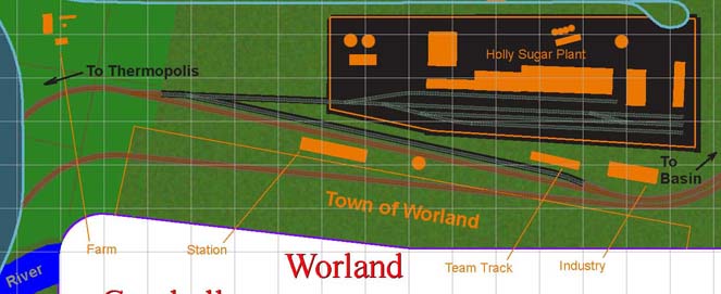 North is to the right in this diagram - Worland is on the opposite side of the upper deck peninsula from Basin. To the left the track heads into the helix, from which it emerges on the lower level en route to Thermopolis.
This plan is in an intermediate stage between "place holder" and "final." The tracks shown for sugar plant are just first approximations. Research will provide more data on an appropriate alignment, as well as data on what types of products came into the plant, and how the finished products were shipped out. This is also true of other industry in Worland.
Whether the sugar plant requires its own switcher is still an open question, but I rather suspect it will. This plant, even in the 1930s and 1940s, was (and still is) huge, compared to most other non-petroleum industrial complexes in Wyoming. I've talked to some of the folks at the sugar plant, and they may be able to provide me with data about the plant from back in the modeled period.
With the sugar plant bringing in sugar beet hoppers from Lovell, Powell and other locations (on and off the layout), plus all the products being shipped out, Worland will be one of the hot spots for local action on the layout, along with Cody and Casper, and Frannie and Orin Junction.
Worland sits right near the Big Horn River, seen in the lower left-hand corner of the diagram, which provides irrigation for the farms surrounding the town. One of those can be seen above the river, adjacent to the light blue backdrop which hides the helix. The Big Horn is the same river as the Wind River - it changes names at the north end - the outlet end - of the Wind River Canyon. Why this river changes names I do not know.